MINNESOTA CLEAN WATER FUND
On November 4, 2008, Minnesota voters approved the Clean Water, Land & Legacy Amendment to the constitution to:
CLICK HERE to learn more about the Minnesota Clean Water Fund.
Board of Water and Soil Resources Clean Water Fund Grant Recipients.
On November 4, 2008, Minnesota voters approved the Clean Water, Land & Legacy Amendment to the constitution to:
- protect drinking water sources;
- protect, enhance, and restore wetlands, prairies, forests, and fish, game, and wildlife habitat;
- preserve arts and cultural heritage;
- support parks and trails;
- and protect, enhance, and restore lakes, rivers, streams, and groundwater.
CLICK HERE to learn more about the Minnesota Clean Water Fund.
Board of Water and Soil Resources Clean Water Fund Grant Recipients.
See West Polk SWCD's Clean Water Legacy Projects on Story Map

FY20 Glacial Ridge Prairie Core Area Cooperative Invasive Species Management Area (CISMA) - $20,000
This project is the establishment of a collaborative partnership of all members of Glacial Ridge Local Technical Team through the Minnesota Conservation Prairie Plan. The Glacial Ridge Prairie Core Area identified in the Minnesota Prairie plan will be used to prioritize and target these management efforts through a landscape approach. This partnership will become the planning group to develop the Glacial Ridge Prairie Core Area CISMA plan consisting of management strategies including, education/outreach, implementation, cost share incentives and monitoring efforts.
This project is the establishment of a collaborative partnership of all members of Glacial Ridge Local Technical Team through the Minnesota Conservation Prairie Plan. The Glacial Ridge Prairie Core Area identified in the Minnesota Prairie plan will be used to prioritize and target these management efforts through a landscape approach. This partnership will become the planning group to develop the Glacial Ridge Prairie Core Area CISMA plan consisting of management strategies including, education/outreach, implementation, cost share incentives and monitoring efforts.
| Glacial Ridge LTT CISMA Strategic Plan | |
| File Size: | 1981 kb |
| File Type: | |
| Glacial Ridge Prairie Core Area CISMA Approved Workplan | |
| File Size: | 207 kb |
| File Type: | |
CONGRATULATIONS WEST POLK SWCD for 2018 Recognition Award!

West Polk SWCD was awarded and recognized at the 2018 MN Association of Soil and Water Conservation Districts (MASWCD) Annual Convention held in Bloomington, MN for the DNR Ecological and Water Resources Appreciation Award. This award honors an SWCD that has implemented innovative conservation activities, demonstrated leadership and achieved significant results in the protection of Minnesota’s land and water resources. Projects highlighted where the restoration efforts on the Grand Marais Creek north of East Grand Forks, MN, and restoration efforts on the Sand Hill River east of Fertile, MN.

FY2018 and FY2019 Clean Water Fund SWCD Local Capacity Services - $100,000-FY18 and $103,920-FY19
This is a non-competitive grant allocation that has been developed to support SWCD local capacity to implement their authorize in Minn. Stat. sections 103C.321 and 103C.331.
West Polk Soil and Water Conservation District Local Capacity funding has been targeted and utilized for soil erosion resource concern through the project development, cost share/incentives, technical services and administration. This funding is essential to district programs that have been historically underfunded.
| FY2018 All Details Report | |
| File Size: | 202 kb |
| File Type: | |

FY2017 Clean Water Legacy Projects & Practices Red Lake Watershed District Project 134, Polk County Ditch 63 - $103,000
The project will install one grade stabilization structure (NRCS Conservation Practice Code 410) within the channel which outlets into the Burnham Creek channel and two side water inlets with buffers. The eroded portion of the project area is approximately down cut 6-8’at the proposed structure site to the head cut 500’ upstream which it meets the constructed channel grade. Two side water inlets with buffers will be installed upstream at 2,600’ and 3,500’, placed on the south side of the reach to control two existing field drainages where gully erosion and sediment deposition is presently active. The proposed erosion control project will stabilize the existing main channel which flows to the Burnham Creek. The project area stretches 2.89 miles, (15,260 linear feet). The drainage area upstream of the project consists of 4.03 square miles, approximately 2,580 acres of agriculture land, and a portion of the lower sector of the industrial park within the City of Crookston, MN. Further upstream, outlets of field drainage continue to erode, creating gullies with potential loss of agricultural land. This is extremely troublesome because the actively eroding coulee outlets into Burnham Creek which outlets into the Red Lake River approximately 4 miles west of the city of Crookston, MN.
The project will install one grade stabilization structure (NRCS Conservation Practice Code 410) within the channel which outlets into the Burnham Creek channel and two side water inlets with buffers. The eroded portion of the project area is approximately down cut 6-8’at the proposed structure site to the head cut 500’ upstream which it meets the constructed channel grade. Two side water inlets with buffers will be installed upstream at 2,600’ and 3,500’, placed on the south side of the reach to control two existing field drainages where gully erosion and sediment deposition is presently active. The proposed erosion control project will stabilize the existing main channel which flows to the Burnham Creek. The project area stretches 2.89 miles, (15,260 linear feet). The drainage area upstream of the project consists of 4.03 square miles, approximately 2,580 acres of agriculture land, and a portion of the lower sector of the industrial park within the City of Crookston, MN. Further upstream, outlets of field drainage continue to erode, creating gullies with potential loss of agricultural land. This is extremely troublesome because the actively eroding coulee outlets into Burnham Creek which outlets into the Red Lake River approximately 4 miles west of the city of Crookston, MN.
| Red Lake Watershed District Project 134, Polk County Ditch 63 Approved Workplan | |
| File Size: | 215 kb |
| File Type: | |

FY2016 and FY2017 Clean Water Fund SWCD Local Capacity Services - $115,337-FY16 (amendment) and $100,000-FY17
This is a non-competitive grant allocation that has been developed to support SWCD local capacity to implement their authorize in Minn. Stat. sections 103C.321 and 103C.331.
West Polk Soil and Water Conservation District Local Capacity funding has been targeted and utilized for soil erosion resource concern through the project development, cost share/incentives, technical services and administration. This funding is essential to district programs that have been historically underfunded.
| FY16 SWCD Local Capacity Grant Agreement Amendment | |
| File Size: | 130 kb |
| File Type: | |
| FY16 SWCD Local Capacity Approved Workplan | |
| File Size: | 206 kb |
| File Type: | |

FY2015 Practices & Projects Clean Water Legacy Sand Hill River Rock Riffle Project - $475,000
This project consists of installation of 16 rock riffles and 2 rock arch rapids to control the grade and stabilize the channelized reach of the Sand Hill River, which contributes thousands of tons of sediment downstream. The total project length is 5 miles of channel located between the cities of Fertile and Beltrami in western Polk County. The entire Sand Hill River is currently impaired for turbidity. It has been estimated that 2,270 tons of sediment per mile is lost from the channelized reach bed and banks each year.
This project consists of installation of 16 rock riffles and 2 rock arch rapids to control the grade and stabilize the channelized reach of the Sand Hill River, which contributes thousands of tons of sediment downstream. The total project length is 5 miles of channel located between the cities of Fertile and Beltrami in western Polk County. The entire Sand Hill River is currently impaired for turbidity. It has been estimated that 2,270 tons of sediment per mile is lost from the channelized reach bed and banks each year.
| Sand Hill River Rock Riffle Project Approved Work Plan | |
| File Size: | 214 kb |
| File Type: | |

Ecofootprint Program Grant Awarded to West Polk Soil and Water Conservation District
The West Polk Soil and Water Conservation District in Crookston, MN was the recipient of a $100,000 Enbridge Ecofootprint Grant.
Donated funds shall be allocated to fulfill remaining costs of the Sand Hill River Rock Riffle Project that was partially funded by the Board of Water and Soil Resources Clean Water Legacy Fund in early 2015. This project involves the design and installation of rock riffles structures that reduce erosion, improve water quality and clarity and provide aquatic wildlife habitat. Enbridge is pleased to be providing a total of $3 million in funding over three years to help protect and restore the natural environment in communities in North Dakota, Minnesota and Wisconsin along the Sandpiper and Line 3 Replacement Projects. Eligible organizations include non-profit 501(c)3 organizations, Native American tribes, state government agencies, local governments and post-secondary academic institutions. Enbridge has selected the Minnesota Association of Resource Association of Resource Conservation and Development Councils to administer the grant program. Interested applicants can learn more about the grant program by visiting www.minnesotarcd.org or Enbridge.com/ecofootprintgrant for details.
Read and see more of this project at Enbridge Blog.
Article from the Grand Forks Herald - "A prairie stream gets a much-needed over"

FY2015 One Watershed Once Plan Pilot
The Red Lake River Watershed is one of 5 selected areas for the BWSR Statewide Water Initiative, One Watershed One Plan.
This watershed basin includes West Polk SWCD, Red Lake Watershed District, Red Lake County SWCD and the Pennington SWCD.
Click here for more information
The Red Lake River Watershed is one of 5 selected areas for the BWSR Statewide Water Initiative, One Watershed One Plan.
This watershed basin includes West Polk SWCD, Red Lake Watershed District, Red Lake County SWCD and the Pennington SWCD.
Click here for more information
| FY15 One Watershed One Plan (1W1P) Approved Work Plan | |
| File Size: | 270 kb |
| File Type: | |

FY2015 SEDLCP Clean Water Legacy Burnham Creek Watershed Restoration Project, Phase II - Inventory - $45,000
Phase II of the Burnham Creek Watershed Restoration Project is to conduct inventory on 2,050 acres, 85.4 miles of ditch channel within the Burnham Creek Watershed of West Polk County. This will consist of surveying, assembling all available GIS data, ArcMap, Li-DAR, review aerial photography, location of tile intakes, determine size of the erosion site (survey's), and prioritization of severity. Partnering efforts with the Area DNR Hydrologist and the Polk County Highway Department-Drainage & Ag Inspector to verify dataset and determine any additional ditch segments. Share results with District Supervisor's, DNR, Polk County Highway Department-Drainage & Ag Inspector, Red Lake Watershed District, Houston Engineering, and MPCA. Coordinate and conduct technical team meetings. Once data has been collected, collaborated and prioritized, Phase III will be started. This will consist of the District staff contacting and working with the landowners and operators within the project area to develop site specific best management practice recommendations which will reduce soil erosion and sedimentation.
Phase II of the Burnham Creek Watershed Restoration Project is to conduct inventory on 2,050 acres, 85.4 miles of ditch channel within the Burnham Creek Watershed of West Polk County. This will consist of surveying, assembling all available GIS data, ArcMap, Li-DAR, review aerial photography, location of tile intakes, determine size of the erosion site (survey's), and prioritization of severity. Partnering efforts with the Area DNR Hydrologist and the Polk County Highway Department-Drainage & Ag Inspector to verify dataset and determine any additional ditch segments. Share results with District Supervisor's, DNR, Polk County Highway Department-Drainage & Ag Inspector, Red Lake Watershed District, Houston Engineering, and MPCA. Coordinate and conduct technical team meetings. Once data has been collected, collaborated and prioritized, Phase III will be started. This will consist of the District staff contacting and working with the landowners and operators within the project area to develop site specific best management practice recommendations which will reduce soil erosion and sedimentation.
| Burnham Creek Watershed Restoration Project Phase II - Inventory Approved Workplan | |
| File Size: | 206 kb |
| File Type: | |

FY2013 Clean Water Legacy Projects & Practices Burnham Creek Watershed Restoration Project, Phase I - $208,610
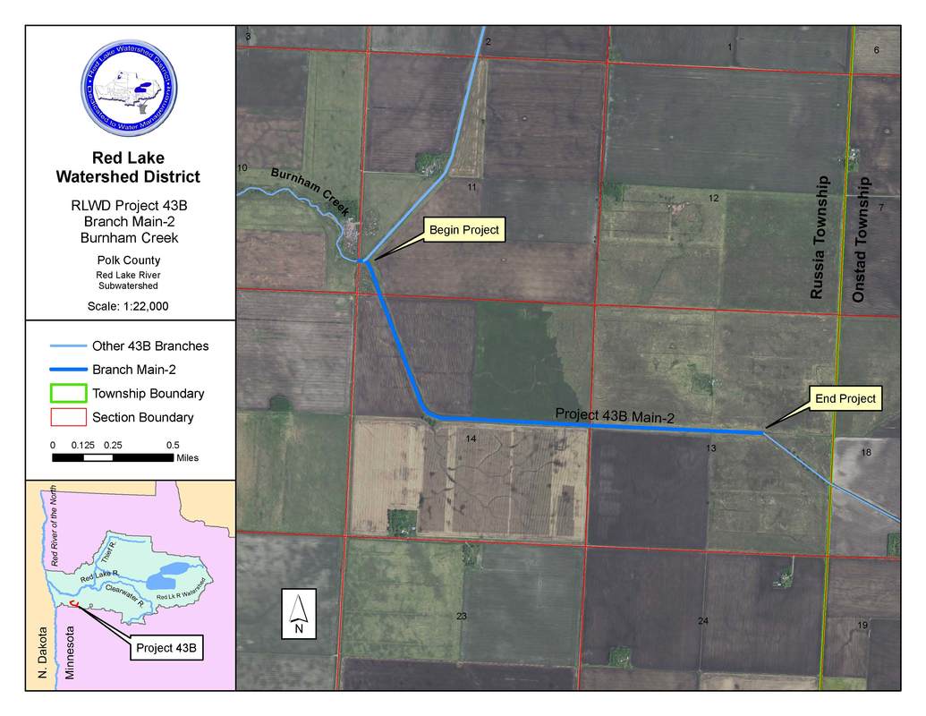
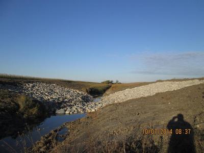
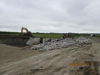
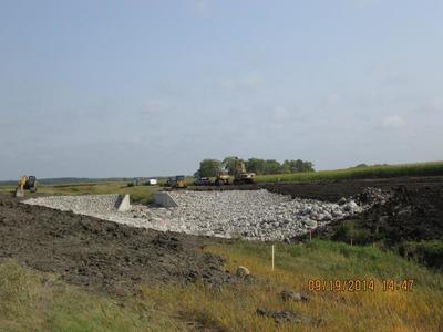
The West Polk Soil and Water Conservation District, in partnership with the Red Lake Watershed District, were awarded a Minnesota FY2013 Clean Water Assistance Grant Clean Water Land and Legacy Amendment, through the Board of Water and Soil Resources. This funding is for the Burnham Creek Watershed Restoration Project, Phase 1. Phase 1 concentrates on a portion of the upper end of the Burnham Creek Channel, located in T148N R46W, sections 11, 13, & 14, Russia Township, West Polk County MN, for a total length of 2 miles, (approx. 10,708 feet). Severe down cutting of the bottom of the channel has been occurring over the past 20 years. This is causing bank failure; sediment has blocked numerous side water inlet pipes, several road crossings, and restricted flow through the culverts. An estimated total loss of soil is approximately 117 tons per year. This “loss” is adding to the existing poor water quality, reduced flows, causing crop loss and localized flooding, damaging roads and inhibiting fish life. A series of rock weirs will be placed at the optimum locations which would flatten out and stabilize the grade.
The West Polk Soil and Water Conservation District, in partnership with the Red Lake Watershed District, were awarded a Minnesota FY2013 Clean Water Assistance Grant Clean Water Land and Legacy Amendment, through the Board of Water and Soil Resources. This funding is for the Burnham Creek Watershed Restoration Project, Phase 1. Phase 1 concentrates on a portion of the upper end of the Burnham Creek Channel, located in T148N R46W, sections 11, 13, & 14, Russia Township, West Polk County MN, for a total length of 2 miles, (approx. 10,708 feet). Severe down cutting of the bottom of the channel has been occurring over the past 20 years. This is causing bank failure; sediment has blocked numerous side water inlet pipes, several road crossings, and restricted flow through the culverts. An estimated total loss of soil is approximately 117 tons per year. This “loss” is adding to the existing poor water quality, reduced flows, causing crop loss and localized flooding, damaging roads and inhibiting fish life. A series of rock weirs will be placed at the optimum locations which would flatten out and stabilize the grade.
| FY13 Burnham Creek Watershed Restoration Phase I Project Grant Report | |
| File Size: | 224 kb |
| File Type: | |


